Last updated on April 13, 2018
We took a close look at the CTI Report into the Pedrógão Grande and Góis fires published in October 2017, translating it and reading it carefully, because a) we wanted to know the detail about what had happened elsewhere while we were busy evacuating, and b) we wanted to know the whole truth about the event rather than just the snippets the press choose to publish.
We also read the IMPA report on the Pedrógão Grande which clarified the meteorological conditions that made the Pedrógão Grande so exceptional, with fire behaviour that could never have been predicted in Portugal or in Europe. We have included some basic meteorological and scientific fire explanations in this article in case, like us, your physics has become a bit rusty.
Cause Of The Pedrógão Grande Fire
There were initial reports circulating after the fire which suggested lightning as the cause of the first ignition. However, the subsequent analysis of all lightning, both cloud-to-soil and intra-cloud, that occurred within in a wide radius of the reported place and time of fire ignition point, concluded…
“a low probability, not null, occurrence of cloud-soil discharges in the vicinity of the beginning site of the fire of Pedrógão Grande”.
IPMA – Incêndio de Pedrógão Grande – Relatório Junho 2017
The cause of the initial ignition of the Pedrógão Grande fire was stated in a GNR report as contact or discharge from a medium voltage power line which had a 500 metre extension without a protection strip. Damage was observed a 3 points on the line.
The Polícia Judiciária deem this was a fire of accidental cause.
The CTI report 12 October 2017 (Relatório da Comissão Técnica Independente) reveals the chronological order of events during the Pedrógão Grande fire…(The details of the Góis fire are not included except it’s ignition time and when it merged with the Pedrógão Grande fire on the 20 June).
Pedrógão Grande Fire Timeline
17 June 2017
14.30 to 16.00 Fire Summary
Hours Area Burnt | Meteorology | Fire Behaviour | Difficulty Of Control |
|---|---|---|---|
14:30 to 16:00 25 ha | Very low fuel humidity (~ 4%) . Early weak wind, with progressive increase in velocity. | About 0.5 h after ignition: propagation speed moderate to high, and extreme intensity with crown fires depending on the slope and vegetation. | Fire head intermittently above the extinction capacity around 0.5 h after ignition. Opportunities for success in flanks. Containment by means of increased attack would possibly be compromised by secondary outbreaks. |
14.39
- Local villagers reported a fire in the Frades river valley by telephone.
- District Command of Relief Operations (CDOS) of Leiria received the fire alert at 14.39.
14.42
- The fire was first detected by meteorological satellite in an oak dominated forest in the Frades river valley 0.6 km north of the village of Escalos Fundeiros.
- The plume of smoke was visible on the IPMA (Instituto Português do Mar e da Atmosfera) radar images from 15.10.
- The vertical column of light grey smoke was about 1 metre in diameter.
- Wind direction N→S light
14.43
- Operational Decision Support System (SADO) recorded the alert .
- 3 VFCIs (Veículo Florestal de Combate a Incêndios) were dispatched from the Fire Departments (CB) of Pedrógão Grande, Castanheira de Pera and Figueiró dos Vinhos.
- A light H31 fire-fighting helicopter was dispatched from Ferreira do Zêzere.
14.52
- The Góis fire first alert was received.
- The ignition, caused by lightning, originated in a valley 0.5 km west of Fonte Limpa.
15.05
- Light H31 fire-fighting helicopter arrived at fire.
15.10 approx
- Wind speed increase.
- Fire spread speed estimated at 0.47 km / hour
- Fire intensity of flanks increased on a 25% slope with pine and eucalyptus vegetation and ground fuel.
- Fire head intermittently above the extinction capacity.
- From the origin the fire spread along the valley from north to south, following the predominant direction of the wind.
- The 600-900 metre plume of the fire was relatively vertical and was oriented towards SSE.
16.00 to 18.00 Fire Summary
Hours Area Burnt | Meteorology | Fire Behaviour | Difficulty Of Control |
|---|---|---|---|
16:00 to 18:00 416 ha | Fuel humidity continues to increase. Influence of instability of the convective system begins to be felt, with the wind speed increasing with strong gusts. | High speed of propagation and intermittent extreme intensity. Increase in quantity and distance of incandescent projection materials. | Fire head intermittently above the extinction capacity with heavy air combat. Containment of flanks possible in expanded and well-organised attack mode but compromised by secondary foci. |
16.00
- A 2nd ignition was reported by villagers near Regadas Cimeiras, 2.8 km northwest of the 1st ignition.
- Ignition was said to be due to the formation of a voltaic arc after the power line overloaded after the discharge at Escalos Fundeiros.
16.00 to 18.00
- Wind direction maintained NNW → SSE until 18.00
16.20
- ANCP and GNR report incapacity to control the fire.
16.30
- Reported occurrence of many airborne projections resulting in secondary spot fires.
16.50
- The fire plume billowing in size and already registered the influence of the convective instability (see below) and changes to NNE orientation, which is maintained until 19.00
- Head fire spread speed estimated at 1.2 km / hour, expanding at 195 hectares / hour.
- Fire head intensity above the extinction capacity.
- ANCP and GNR report incapacity to control the fire verified.
17.33
- New outbreaks reported presumably caused by lightning.
- One of which occurred near Valongo causing a fire to the south and then to the west of the main fire.
18.00 to 19.00 Fire Summary
Hours Area Burnt | Meteorology | Fire Behaviour | Difficulty Of Control |
|---|---|---|---|
18:00 to 19:00 1211 ha | Fuel humidity continues to rise. The general wind direction is from the east and reaches maximum intensity at 18:00. Conditions under the influence of the downburst | Dominated by the convection column, with formation of pyrocumulonimbo. | Speed of propagation and intensity compares to the previous period. Sharp vorticity and increase in quantity and distance of projections. Uncontrollable, regardless of means available. |
18.00
- Wind direction rapidly changed to blow ENE → WSW, increasing in strength. As a result the fire dramatically changed direction – perpendicular to the previously prevailing direction.
- 416 hectares burnt.
- Fire arrives in Troviscais and close to the industrial area of Pedrógão Grande.
- Head fire spread speed doubled to 2.3 km / hour and tripling the speed of expansion of the perimeter to 585 hectares / hour.
- Reports from the ANCP and GNR of “extreme intensity in canopies” and “flames over 40 metres”
- Flames sighted for the first time in Vila Facaia and in Sarzedas de S. Pedro due the projection of incandescent material creating fires. The main fire front was 4 to 5 km away at the time.
18.30
- Pyrocumulmonimbus cloud (fire-fuelled thunderstorm cloud) was first visible in satellite imagery.
19.00 to 20.00 Fire Summary
Hours Area Burnt | Meteorology | Fire Behaviour | Difficulty Of Control |
|---|---|---|---|
19:00 to 20:00 3799 ha | Wind gusts progressively stronger and more erratic. Convective outflow at its maximum conjugated with the weather generated by the convection column. | Reinforcing the characteristics of previous period with quasiduplication speed and intensity of fire. Maturation of convection column with progressive increase in force and altitude. | Uncontrollable, regardless of means available. |
19.00
- The west fire front was about 5 km long and approaching Vermelho e Coelhal to the north and Mosteiro to the south.
Some basic meteorology to help explain the extraordinary Pedrógão Grande fire…
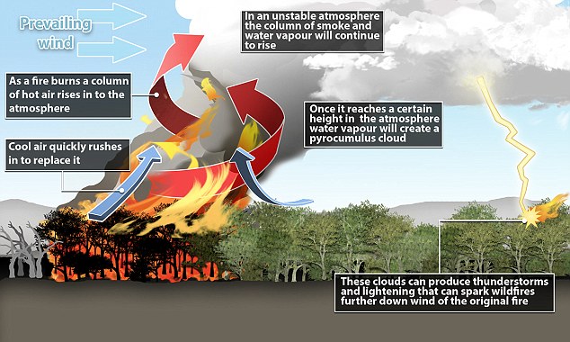
Convection: The transfer of heat by the movement of a gas or liquid. Because hot air rises, heat transfer through convection tends to move upward. During wildfires, burning materials on the forest floor create convection currents that preheat the leaves and branches of trees above the fire. The vertical air currents can also lift burning materials.
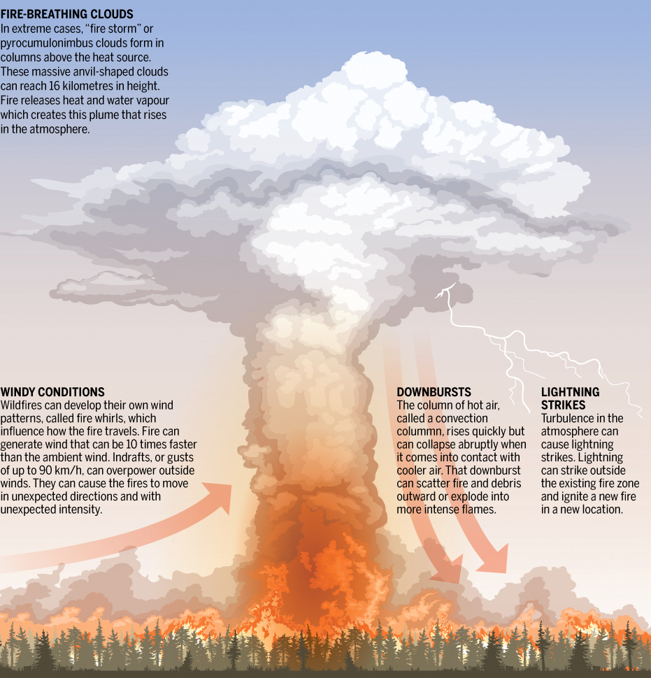
Convection column is an ascending column of gases, smoke and debris produced by the heat of a fire that generates powerful updrafts. The height of a column into the atmosphere depends on the degree of atmospheric instability, heat output of the fire and speed of higher altitude winds. The heat also propels moisture that condenses into pyrocumulus clouds.
Pyroconvection is the vertical transport of atmospheric properties driven by or enhanced by fire.
Pyrocumulus Clouds are puffy cumulus clouds formed by the hot air and smoke released into the sky during wildfires. If a cloud column builds high enough, it can become a…
Pyrocumulonimbus cloud which is essentially, a fire-fuelled thunderstorm cloud. The anvil-shaped thunderheads on top of the smoke plumes spawn extreme turbulence, down-drafting winds, and even hail that, rather than cooling flames, stokes them by churning out even more erratic winds. They can also produce lightning.
Convective Instability is the effect of atmospheric conditions such as changes in temperature, moisture and pressure. If the air is unstable, the vertical movement of air is encouraged, and this tends to increase fire activity.
Convective cells are the result of hot air rising, losing density, cooling and gaining density then falling to earth. This process forms the basis of wind, cloud and thunderstorm development.
Downburst is a strong ground-level wind system that emanates radially from the surface landing point in a straight line in all directions. They can contribute to very sudden changes in surface winds, moisture and temperature.
Radiation is the mechanism by which burning objects release energy in the form of heat. In general, the size of the burning object determines the amount of radiant heat released, with larger fuels burning hotter. In most cases, radiant heat from a wildfire will not ignite materials at distances greater than approximately 10 metres.
Conduction is the last mechanism of heat transfer is from direct contact or conduction. Conduction carries heat through fuels, such as deadwood or forest debris and can raise the temperature of fuels to the point that they ignite.
19.00 to 20.00
- The fire gains the intensity and dimension in this next hour that resulted in fatalities.
- Head fire spread speed reached 3.9 km / hour.
- The perimeter expansion velocity rose to 2589 hectares / hour and the burning area was 3799 hectares by 20.00.
- In the north the fire spread beyond Feteira and approached Moita and Sarzedas do Vasco.
- In the south the fire passed Salaborda Nova and Campelos and arrives at Villa Facaia.
- Further south, the fire crossed the IC8, passes Outão and approached Adega and Pinheiro Bordalo.
19.15
- The pyrocumulmonimbus cloud formed by the fire increased in density.
19.23
- The most active phase of the fire begins.
- A horizontal front of very strong turbulent gusts of wind started – GNR in Vila Facaia reported their car violently shaking and difficulty opening car door.
19.30
- Atmospheric flow was from SE → NW
- Plume speed increased significantly until 20.20 resulting with it reaching an altitude of 13 km. This was 3 km above the anvil-shaped pyrocumulonimbus cloud which had formed over the plume. This was position was maintained for 10 minutes.
19.50
- Numerous fast growing secondary fires were reported such as at Alagôa.
20.00 to 21.00 Fire Summary
Hours Area Burnt | Meteorology | Fire Behaviour | Difficulty Of Control |
|---|---|---|---|
20:00 to 21:00 8258 ha | Downburst caused by fall of convection column. | Collapse of the convection column, resulting in "rain" of projections, with junction between foci and their interaction with the propagation front, resulting in sudden advances of the fronts of flames and ignition phenomena in area. The fire propagation of 15 km / h for 10 minutes resulted in the majority of fatalities. | Uncontrollable, regardless of means available. |
20.00 to 21.00
- Area burned increased to approximately 4459 hectares.
- Fire spread speed increased to 3 km / hour on SE→NW axis.
- Fire spread speed increased to 4.0 km / hour on NE→SW, E→W & S→N axes.
20.00 – 20.10
- In 10 minutes the top of the plume abruptly abruptly collapsed in altitude from 13 km to about 6 km.
- This rupture of the convective column caused a local ‘downburst’ which dramatically changed the fire behaviour – witnesses reported a sudden ‘bomb’ of fire spreading tongues of flames and sparks in all directions.
- This sudden and extreme event triggered the escape of villagers and overwhelmed those already on the roads.
- The fire spread from Vila Facaia to EN 236-1 in 10 minutes.
- Fire spread speed increased to 15.0 km / hour
- “Highest wind speed value observed by radar in the area of Mação, was approximately 117 km / hour to about 650 m
of altitude in association with a convective cluster” IMPA Report. - “Convective outflow spreading over the region of the fire of Pedrógão Grande and may have reached 70 to 90 km / hour, depending on the terrain” IMPA Report.
20.30
- There was a further increase in the plume intensity which rose again to an altitude of 13.5 km, possibly causing a second downburst.


