Last updated on April 12, 2018
There is not much of rural Central Portugal that is not on or near a slope. It is these beautiful forested hills and panoramic views that attract tourists and property buyers, particularly those who have ‘a view’ as one of their top house search criteria. If this is the case…buyer beware…of wildfires on slopes.
A house situated anywhere on a significant slope – mid-slope, at the base or crest and surrounded by flammable vegetation, is in the most dangerous location when it comes to wildfires. It is not an exaggeration to say…don’t be tempted to build or buy a house on a steep hillside because of a wonderful view – it could cost you your home. It is also a location that is difficult and dangerous for firefighters to defend.
Additionally, if a house on a slope more or less survives a severe fire which has burnt the up-slope forest, vegetation and soil, it may be at risk of flooding, landslides and debris flows due to increased run-off after intense rainfall. The fires of 2017 have also revealed many old and abandoned terraces in the landscape which may collapse or induce further landslides due to ground water saturation.
If you are considering buying or building a house on flat land bordering (an unburnt and uncleared) forest, you might be well advised to closely check the gradient of the forest (if you can actually get into it). After the fire, we found a newly revealed significant slope which was previously completely obscured by decades-worth of forest litter and trees. This, along with the extraordinarily strong winds, may have accounted for the great speed of the fire as it roared up-slope towards our house.
Slopes and fire susceptibility in Portugal
The Susceptibility map (bottom) predicts wildfire risk based on Slope (left) and 2006 Vegetation cover (right). The slope includes the variables of elevation, temperature and precipitation, all of which affect the type and amount of vegetation. (Corine land cover means ‘coordination of information on the environment’, a project initiated by the EU in 1985).
The fire susceptibility risk model also takes into account not only the natural consequence of slope enhancing the propagation of fire but also the fact these regions are more isolated and less accessible for fire-fighting.
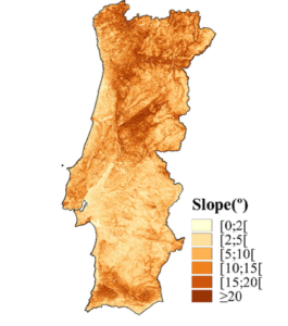
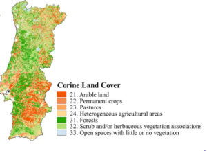
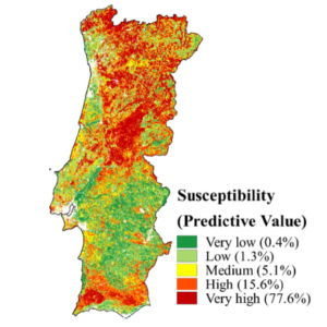
Source: J Parentes (2016)
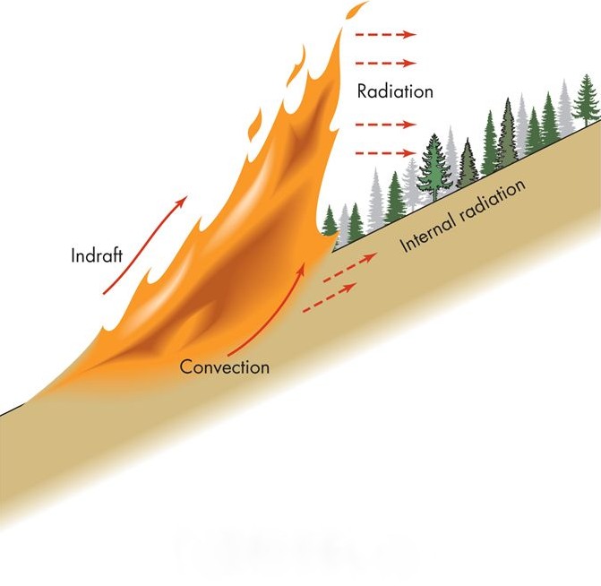
How does a slope affect wildfire behaviour?
- During the day the warmed surface of a slope creates less dense air next to the surface.
- This lighter air rises along the slope causing a draught.
- As the lighter air moves up the slope, cooler air replaces it below.
- Consequently local winds blow up-slope.
- It is because of these up-slope winds, that wildfires usually burn up-slope.
- The steeper the slope, the faster and more intense the fire will burn.
- The fire develops greater radiant and convective heat.
- The fire pre-heats (radiant heat) the fuel ahead of it as the flames are closer to the up-slope.
- This results in even further pre-heating and faster fuel ignition.
- The now fire-heated air rises along the slope increasing the wind draught which increases the rate of fire spread. These up-slope winds can reach 8 to 16 km / hour speeds, depending on the gradient and length of the slope.
- The increase in wind draught up-slope also causes more convective heat to reach the fuel ahead which is pre-heated faster to ignition temperature.
- This preheating of the vegetation is not limited to the surface fuels but can also include aerial fuels, particularly those in the tree canopy.
- Fires on steep slopes will normally develop a narrower and more intense head fire.
- If a fire is at the bottom of a slope, the entire slope to the ridge top lies in the path of the fire. Such fires will usually be larger because most are not controlled until they reach the top of the ridge.
The wind pattern reverses at night when a slope becomes shaded. The surface loses heat rapidly and becomes cool, the adjacent air also cools and becomes more dense so it flows down a slope.
How the aspect, or orientation to the sun, of a slope affects fire behaviour
- South-facing slopes become warmer and drier throughout the day, whilst north-facing slopes remain cooler and damper.
- The amount of heat the surface absorbs influences the temperature and humidity of the air and therefore the combustibility of available fuels.
- Generally fires that occur in fuels that have had more sun pre-heating will be more intense.
Convection is the transfer of heat by the movement of a gas or liquid. Because hot air rises, heat transfer through convection tends to move upward. During wildfires, burning materials on the forest floor create convection currents that preheat the leaves and branches of trees above the fire. The vertical air currents can also lift burning materials.
Radiation is the mechanism by which burning objects release energy in the form of heat. In general, the size of the burning object determines the amount of radiant heat released, with larger fuels burning hotter. In most cases, radiant heat from a wildfire will not ignite materials at distances greater than approximately 10 metres.
Local winds are those created by conditions specific to a particular area, such as terrain and topography.
Wildfire behaviour on a ridge
Ridges are features formed between two opposing slopes. When a fire reaches the ridge or top of a slope it changes its behaviour and unless there is a particularly strong wind, it will usually reduce its intensity and rate of spread. A fire may hang around on a ridge because the change of air from up-slope to down-slope is usually gradual.
Ridges are sometimes the most suitable locations to construct a fire break because when the fire reaches the ridge line it loses alignment with the supporting slope and its intensity and rate of spread will reduce.
Wildfire behaviour on a down-slope
When a fire burns down-slope the up-slope process is almost reversed, so…
- There is a widening of the gap between the available fuel and the fire.
- The speed of the fire will slow and its intensity will reduce. Down-slope wind speeds may reach 3 to 5 km / hour.
- There is the possible hazard of burning material rolling down hill and igniting fuels ahead of the fire.
- Occasionally a down-slope fire may reach a point where it can start to turn and burn up-slope. This change can result in a sudden increase of intensity and speed of the fire.
How the shape of a slope may affect wildfire behaviour…
- Straight slopes will have a more even and predictable rate of fire spread.
- Concave slopes have an increased angle of slope nearer the top which can cause a significant increase in fire intensity as it moves up-slope. A fire moving down a concave slope will gradually increase in intensity as the angle of the slope decreases nearer the bottom where more heat can be transferred to the unburnt fuels.
- Convex slopes have a steeper angle at the base compared with the top, so a fire is likely to be more intense at the base of the slope. As the fire moves up-slope the angle of slope lessens and the amount of heat transferred to the unburnt fuel is reduced.
Terraced slopes
Many slopes in Portugal are, or were, terraced to increase crop productivity on a steep hillside, many of which are now abandoned and overgrown with crumbling retaining walls. The steep walled rises of the terraces are usually covered with thick vegetation which facilitates fire spread. When an up-slope wildfire reaches terrain with a series of terraces (steep rises with flatter ground between) it spreads rapidly up the steeper parts and slows down on the flatter area before pushing on to the next rise.
Other topographical features may affect wind and wildfire behaviour…
- Saddles – curvature in the landscape formed between two areas of higher ground which may cause the wind passing within saddles to concentrate and fluctuate or alter direction.
- Spurs – which are often steeper than the slopes that surround them which may alter a fires speed, direction and intensity.
- Gullies – sharp cuts in the landscape often with steep sides which may act as a funnel for winds to follow and in certain situations concentrate its strength. This can increase fire intensity and rate of spread substantially.
- Narrow valleys or gullies with very steep sides – as a fire moves down one side the heat generated can preheat the fuel on the opposite side resulting in a much more intense fire if slope reversal occurs.
- Drainage slopes – smaller folds in the landscape which can have a significant effect on fire behaviour as they may act as a chimney channelling the wind and concentrating its strength. They are often critical points on the landscape allowing fire to alter its direction and speed of travel.
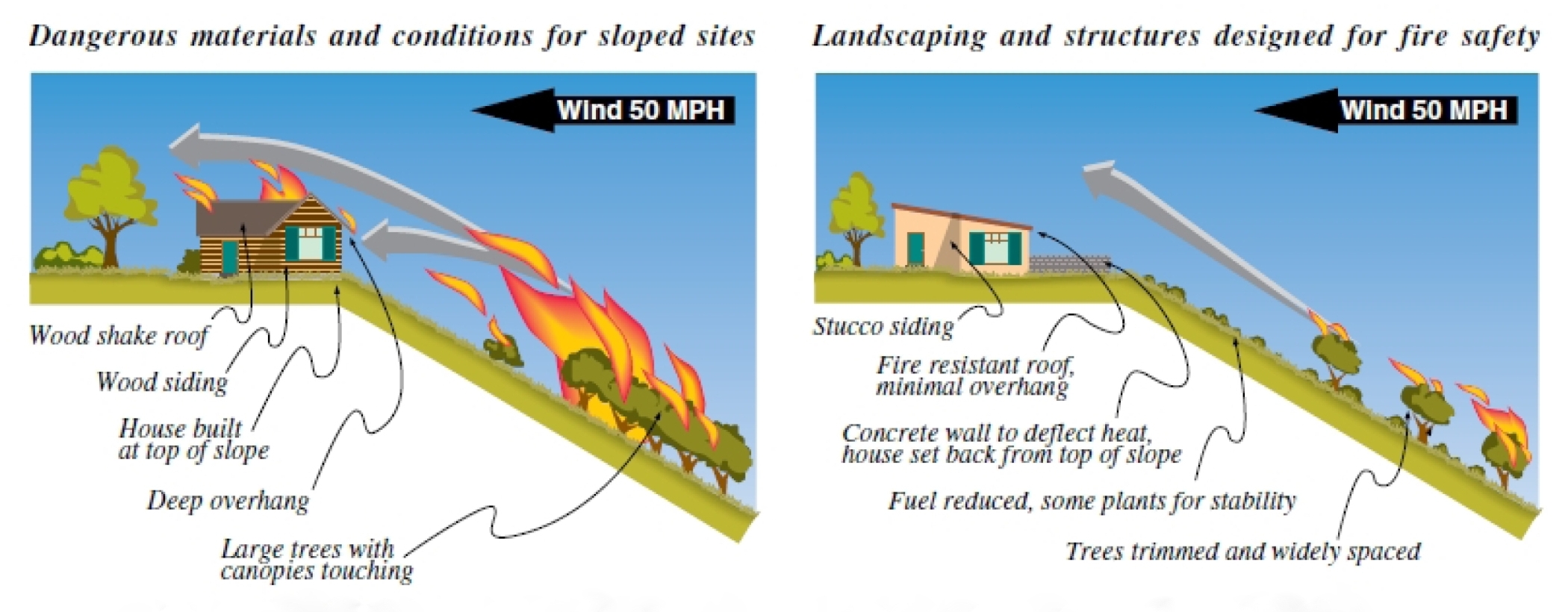
What to do if your house is on a slope
As mentioned already – the steeper the slope the longer the flame lengths and faster-moving the fire. Houses perched on hilltops or sharp ridges can be exposed to wind and fire on all sides. Houses situated on diverging ridges can be affected by fire driven by funnel winds. Houses on the leeward side of a slope, sheltered from wind, may be exposed to extremely intense fire driven by powerful air turbulence as the wind blows over the hill crest creating a leeward low pressure zone.
“At 30 percent slope, rate of fire spread doubles compared to rates at level ground, drastically reducing firefighting effectiveness. Areas near 30 percent or greater slopes are critical and must be reviewed carefully”. Source: Fuel break Guidelines for Forested Subdivisions & Communities by Frank C. Dennis, Colorado State Forest Service.
As said before, in a wildfire prone area, such as Central Portugal, houses on a forested hillside are in one of the least safe places to be during a wildfire. As such, you should be meticulous in taking fire protective measures on the building itself and aggressive fuel management of surrounding vegetation – possible more than Portuguese law currently prescribes.
How many houses have you seen, including newly-built ones, that sit bang on the edge of a precipitous slope covered in pine and/or eucalyptus? In some houses we viewed, you could even touch the top leaves from the balcony, which of course, was made of wood.
It is likely too that a forested slope immediately below a house will belong to someone else, so cleaning the most important defensive zone of vegetation may be very difficult.
- A house should be set as far back as possible from the edge – at least 10 metres but preferably 30 metres or more. Excavate a flat shelf on which to site the house well back from the edge.
- Situate a house well away from the tops of hills or ridges.
- Preferably situate a house on a down-slope plateau area.
- Build a pond or swimming pool as a firebreak and a bank of earth or concrete wall on the aspect facing the top of the up-slope, to protect the house from radiant heat.
- Extend the width of the 1 to 2 metre hard surface around the whole property.
- Design the house with wildfires in mind and use fire-resistant building materials.
Source: East Bay Municipal Utility District – Firescape: Landscaping to Reduce Fire Hazard
Fuel Management On A Slope
Your defensive fuel management width depends on the vegetation type and height, the gradient and length of the slope up and/or down to your property.
Portuguese laws on fuel management widths do not specifically take slopes into consideration – it is a blanket 50 metres of (shaded) fuel break around a building/structure, 100 metres round a population cluster (village) and 10 metres on a road. As you can see from the table below, 50 metres is enough width to cover all but the very steepest gradients but 10 metres is not enough for a road cut into a steep slope.
The owner of any land at risk of fire and where non-concession roads are situated, is also responsible for the fuel management of that road or section of road.
Minimum fuel break distances uphill & downhill depending on slope percentage
SLOPE % | UPHILL DISTANCE METRES | DOWNHILL DISTANCE METRES |
|---|---|---|
0 | 30.5 | 30.5 |
10 | 27.5 | 35 |
20 | 24 | 40 |
30 | 21 | 44 |
40 | 18 | 49 |
50 | 15 | 53 |
60 | 12 | 58 |
Source: F Dennis ( 1983) “Fuel break Guidelines for Forested Subdivisions”
Measurements are from the toe of the hill for downhill distances and above the house for uphill distances. All distances are measured along the slope.
Spacing trees on a slope
As you can see from the table below, the stipulated 10 metres spacing between the canopies of pine and eucalyptus in Portuguese law is adequate for all but the most steep gradients. The stipulated 4 metre spacing for all other trees may need to extended depending on the gradient and height of the trees.
Minimum Horizontal Space - Tree Canopy Edge To Canopy Edge |
|
|---|---|
Slope | Spacing |
0% to 20% | 3 metres |
20% to 40% | 6 metres |
Greater than 40% | 10 metres |
Source: Gilmer M (1994) ‘California Wildfire Landscaping’
Header Photo: Sergio Azenha


